Showing 28 items matching kara kara
-
 Stawell Historical Society Inc
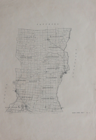
Map, T.F. McGauran, Winjallock County of Kara Kara, 1900
... Winjallock County of Kara Kara...A2 Map0f Parish of Kara Kara.... grampians Map Winjallock County of Kara Kara A2 Map0f Parish of Kara ...Noth of Navarre and BarkleyA2 Map0f Parish of Kara Kara.Photo Lithographed and the department of Lands & Survey, Melbourne by T.F. McCauran 22.10.00survey -
 Federation University Historical Collection
Plan, Kara Kara
... Kara Kara ...kara kara... Plan Kara Kara Printed plan on paper kara kara tatchera ...Printed plan on paperkara kara, tatchera, gladstone -
Stawell Historical Society Inc
Map - Parish Map, Barkley County of Kara Kara 1920's, 1920's ?
... Barkley County of Kara Kara 1920's... grampians Parish Map Map Barkley County of Kara Kara 1920's Paper ...Johnsons Gully LeadPaper map of Parish of BarkelyBy Authority H.J. Green Govt Printer. Photo Lithographed at the Department of Lands and Survey. Melbourne 22.11.2survey -
Stawell Historical Society Inc
Map, 1957
... Bolangum, County of Kara Kara... grampians Map Bolangum, County of Kara Kara Stawell ...Bolangum, County of Kara Karastawell -
Stawell Historical Society Inc
Map, 1925 & 1955
... Navarre, County of Kara Kara... grampians Map Navarre, County of Kara Kara Stawell ...Navarre, County of Kara Karastawell -
Stawell Historical Society Inc
Map, 1954
... Landsborough, County of Kara Kara... grampians Map Landsborough, County of Kara Kara Stawell ...Landsborough, County of Kara Karastawell -
Stawell Historical Society Inc
Map, 1959
... Callawadda, Counties of Borung & Kara Kara... grampians Map Callawadda, Counties of Borung & Kara Kara Stawell ...Callawadda, Counties of Borung & Kara Karastawell -
Stawell Historical Society Inc
Map, 1929
... Glynwylln, Counties of Borung & Kara Kara... grampians Map Glynwylln, Counties of Borung & Kara Kara Stawell ...Glynwylln, Counties of Borung & Kara Karastawell -
Stawell Historical Society Inc
Map, 1958 & 1959
... Kara Kara, Sheet One of Two... grampians Map Kara Kara, Sheet One of Two Stawell ...Kara Kara, Sheet One of Twostawell -
Stawell Historical Society Inc
Map, 1954
... Crowlands, Counties of Borung & Kara Kara... grampians Map Crowlands, Counties of Borung & Kara Kara Stawell ...Crowlands, Counties of Borung & Kara Karastawell -
Stawell Historical Society Inc
Map
... County of Kara Kara Marnoo / Callawadda... grampians Map County of Kara Kara Marnoo / Callawadda Stawell ...County of Kara Kara Marnoo / Callawaddastawell -
Stawell Historical Society Inc
Map, 1946
... Joel Joel, Counties of Kara Kara & Borung... grampians Map Joel Joel, Counties of Kara Kara & Borung Stawell ...Joel Joel, Counties of Kara Kara & Borungstawell -
Stawell Historical Society Inc
Map, 1921
... Malakoff, County of Kara Kara, Shire of Stawell... grampians Map Malakoff, County of Kara Kara, Shire of Stawell ...Malakoff, County of Kara Kara, Shire of Stawellstawell -
Stawell Historical Society Inc
Map, 1920
... Wallaloo, County of Kara Kara, Shire of Stawell... grampians Map Wallaloo, County of Kara Kara, Shire of Stawell ...Wallaloo, County of Kara Kara, Shire of Stawellstawell -
Stawell Historical Society Inc
Map, 1957
... Warngar, County of Kara Kara, Shire of Stawell... grampians Map Warngar, County of Kara Kara, Shire of Stawell Stawell ...Warngar, County of Kara Kara, Shire of Stawellstawell -
Stawell Historical Society Inc
Map, 1953
... Morrl Morrl, County of Kara Kara, Shire of Stawell... grampians Map Morrl Morrl, County of Kara Kara, Shire of Stawell ...Morrl Morrl, County of Kara Kara, Shire of Stawellstawell -
Stawell Historical Society Inc
Map, 1857
... Township of Crowlands, Parish of Crowlands, County of Kara... of Kara Kara Stawell ...Township of Crowlands, Parish of Crowlands, County of Kara Kara stawell -
Stawell Historical Society Inc
Subdivision of Woodlands Estate
... Parishes of Malakoff and Navarre. County of Kara kara... Parishes of Malakoff and Navarre. County of Kara kara Shows ...Shows Homestead Cottage and Dam, Plus Shed. Malakoff NavarreA3 photocopy of MapParishes of Malakoff and Navarre. County of Kara karasurvey -
Stawell Historical Society Inc
Map, Crowlands & Navarre Railway Construction Trust, VR Plan Showing Railway Construction District Crowlands to navarre Line 1916, 4 July 1916
... Shire of Kara Kara. Shire of Stawell Shire of Ararat 4 July.... Scale 40 Chains to 1 Inch. rail Line Drawn in Red Shire of Kara ...Two (2) Very large Coloured Maps. Scale 40 Chains to 1 Inch. rail Line Drawn in RedShire of Kara Kara. Shire of Stawell Shire of Ararat 4 July 1916railways -
Stawell Historical Society Inc
Map, W.J. Butson, Subdivision of North Woodlands Estate 1922, 12.02.1922
... Parishes of Malkaff & Navarre County of Kara Kara... Parishes of Malkaff & Navarre County of Kara Kara Photlithograph ...Two (2) Copies. A1 Maps with Cloth Backing Annotated with Title HoldersParishes of Malkaff & Navarre County of Kara Kara Photlithograph by W.J Butson 12.02.2022farming -
Federation University Historical Collection
Booklet, Ballarat School of Mines, Regional Unemployment: Ballarat School of Mines Planning Document 7:79, 02/1979
... kara kara... bet bet kara kara bungaree buninyong ballan dunmunkle stawell ...White cardboard cover with black plastic spineunempolyment, ballarat school of mines, ballarat, horsham, ararat, mildura, maryborough, tullaroop, creswick, clunes, talbot, st arnaud, bacchus marsh, bet bet, kara kara, bungaree, buninyong, ballan, dunmunkle, stawell, dimboola, lowan, kaniva, kowree -
 Federation University Historical Collection
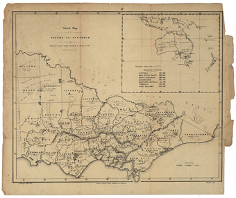
Map, Robert Brough Smyth, Sketch Map of the Colony of Victoria, c1871, c1872
... kara-kara... hampden heytesbury polwarth ripon kara-kara gladstone grenville ...This map includes the population of each County in Victoria according to the 1871 Census, as well as the population of each Australian colony and New Zealand. Telegraph Route is given in a detail at the top right. victoria, victorian counties, robert brough-smyth, telegraph, population, bourke, rodney, dalhousie, evelyn, mornington, buln-buln, tanjil, dargo, delatite, moira, bogong, bendigo, gunbower, grant, talbot, hampden, heytesbury, polwarth, ripon, kara-kara, gladstone, grenville, croajingolong, tambo, benambra -
Federation University Historical Collection
Book, Historic Sites Survey: North Central Study Area, 1979
... , Bet Bet, east Loddon, Goulburn, Untly, Kara Kara, Korong... the Shires of Avoca, Bet Bet, east Loddon, Goulburn, Untly, Kara Kara ...The North Central Study Area included the Shires of Avoca, Bet Bet, east Loddon, Goulburn, Untly, Kara Kara, Korong, Maldon, Marong, Metcalfe, McIvor, Newstead, Strathfieldsaye, Stawell, Talbot, Clunes, Tullaroop and Waranga. 153 page book with white plastic binding. It is an historic sites survey for the North Central Study Area commissioned by the Land Conservation Council, the Ministry for COnservation and the Australian Heritage Commission. castlemaine, mount alexander goldfield, maldon, percydale, warrenmang, moliagul, tarnagulla, stuart mill, the whipstick, whroo, rushworth, graytown ironbark forest, st arnoaud, new bendigo, landsborough, inglewood, kurting, wedderburn, wehla, kooroora, langham flat, mcintyre, rheola, diamond hill, fosterville, coliban water works, green gully, newstead, muckleford forest, costerfield, graytown, bailieston, waranga irrigaiton system, eucalyptus distillery, mia mia bridge, korokubeal township researce, concegella slate quarry, chewton, fryerstown, kingower, timor, talbot, majorca, carisbroook, clunes, st arnaud, taradale, icomos, dunolly, limestone, castlemaine slate quarry, harcourt granite, taradale railway viaduct, loddon united waterworks trust, gouldburn weir, carisbrook lock-up, history of tree planting in streets, history of public reserves, r.u. nicholls nurseryman, thomas lang, francis moss, ballarat botanical gardens, ballarat school of mines botanical gardens, lake wendouree, victoria park, ballarat, muont holled smith, ballaarat old cemetery planting, eastern oval, ballarat east botanical gardens, ballarat east town hall gardens, eureka stockade reserve, ballarat observatory plantings, yarrowee creek plantings, yarrowee bluestone channels, ballarat woollen mill, band and albion mullock heap, black hill plantings, yarrowee creek channels, canadian creek channel, specimen vale channel, poverty point reserve, union jack reserve buninyong, imperial mine, buninyong, victoria street plantings, bridge mall, sturt street gardens, ballarat avenue of honour plantings, white flat oval plantings, camp street, elms, burnt creek -
 Wycheproof & District Historical Society Inc.
Bunguluke Map, Bunguluke District In 1923, 27.2.1923
... in the County of Kara Kara, Number L5149. Marked - Photo Lithographed... in the County of Kara Kara, Number L5149. Marked - Photo Lithographed ...By 1881 Bunguluke was a small settlement as recorded, December 5, in the Charlton "Mercury". It reports that in that year Draper's Store, Hotel and Post Office and residence at Bunguluke North was totally destroyed by fire. For years now there has been little sign of community life with houses few and far between and acreages have gone into larger holdings. The map references land blocks and owners for that era.This important map shows the local land ownership and local features that existed in 1923. This is a photocopied black and white map of Bunguluke in the County of Kara Kara, Number L5149. Marked - Photo Lithographed by W.J. Butson 27.2.1923. The details include numbers of allotments, property owners, roads, rivers. The boundaries marked are the Parish of Jeruk, Parish of Wycheproof, Parish of Cooroopajerrup. Wycheproof township location is shown with the Scale of Chains. Bunguluke maps for other years are also in the collection.map, bunguluke, jeruk, wycheproof, cooroopajerrup -
Stawell Historical Society Inc
Instrument - Realia, Engineering Instruments from Northern Grampians Shire
... metal hinges and catches "Shire of Kara Kara" inscribed... metal hinges and catches "Shire of Kara Kara" inscribed ...1: Small cardboard box with lid containing Silver distance Measurer. This was used for Measuring distances on plans.(Planimeter) 2: Cardboard Box without lid containing three plumbobs: One large turned brass: one small turned metal. One circular silver coloured metal complete with string and winding board. These were used to locate survey equipment above a fixed point. 3: Timber ( Vic Ash?) dovetailed box with brass hinged lid and brass swing catches containing plywood templates called railway curves, used for drawing curves on plans. 4: Cardboard box with lid containing Allbrit panimeter in Bakelite/plastic box with silver metal hinges and catches "Shire of Kara Kara" inscribed on the box. The box contains the original Instructions. The Planimeter was used for calculating areas of Irregular shapes and used for estimating quantities from plans of cut and fill projects, as one example. 5: Timber Box with brass hinges and swing catches wand leather carry Strap containing one set of self adjusting level made by E.R. Watts and Son, London England. Paper label on the inside "Shire of Stawell". Also had paper instructions pasted to the inner lid. The level was used for taking Ground Levels. The first 3 have been in use up until the 1990's, when computer drafting took over the role of these instruments with greater speed and accuracy. The dumpy level would have been superseded in the 1980's when automatic levels became cheaper, and were more accurate. stawell -
 Queenscliffe Maritime Museum
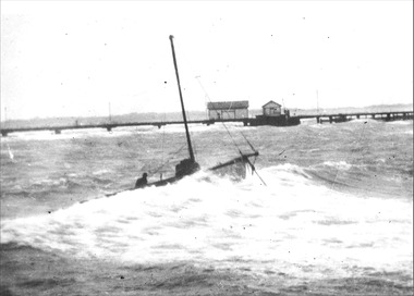
Photograph - Jurgens' Couta boat KARA, KARA, Jurgens' Couta boat, 1953
... Jurgens' Couta boat KARA...KARA, Jurgens' Couta boat...KARA...KARA Couta boat...KARA, Jurgens' Couta boat in SE gale in 1953...Reverse - " late Arnold Jurgens fishing boat KARA / She...-and-the-bellarine-peninsula Jurgens' Couta boat KARA Photograph KARA ...KARA Couta boatKARA Couta boat in a gale.KARA, Jurgens' Couta boat in SE gale in 1953Reverse - " late Arnold Jurgens fishing boat KARA / She was deliberately beached between the piers to save her from being wrecked like the P & H survey launch FLINDERS [refer 1985-146] / South East gale February 1953 "historical references, kara, couta boat -
 Whitehorse Historical Society Inc.
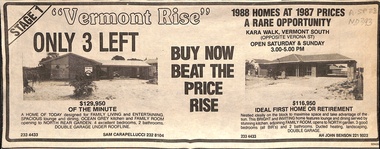
Newspaper - Advertisement, Vermont Rise, 1988
... kara walk..., Kara Walk, Vermont South, 1988.... advertisement for 'Vermont Rise', houses and land, Kara Walk, Vermont ...Newspaper advertisement for 'Vermont Rise', houses and land, Kara Walk, Vermont South, 1988.land sales, vermont rise, kara walk, vermont south -
 Whitehorse Historical Society Inc.
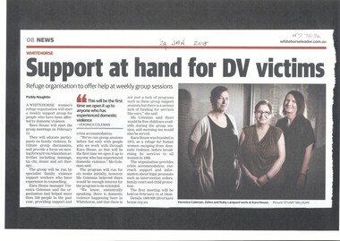
Article, Domestic Violence, 2018
... kara house...Kara House, a Whitehorse women's refuge organization... Mitcham melbourne Article Article Domestic Violence Kara House ...Kara House, a Whitehorse women's refuge organization will start a weekly support group for people who have been affected by domestic violence.city of whitehorse, kara house